
Selection by Minimizing MAE (mean absolute error)
- 5 meter interval sampling of contours
- 5 meter interval sampling of terrain skeleton
- [5 10 15 20 25 30 40 50 60] meter thinning (snapping) radius
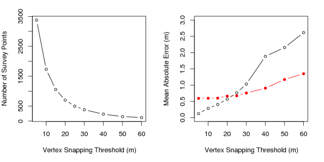
MAE vs. Thinning radius: terrain skeleton approach in red
# # prep work:
g.region res=10

v.to.rast in=w_buff out=w_buff_mask use=val val=1 --o


# invoked like this
# time sh eval_pts_spacing.sh 2>/dev/null

# approx 7 mins


# start logfie
outfile='stats.out'
echo '' > $outfile

# the min distance between new points when converting lines to points
# make this a small number for lots of points
dmax=5

# sequence of thinning thresholds
sequence="5 10 15 20 25 30 40 50 60"

#       loop over final cleaning snapping threhold
for j in $sequence
        do


        # feedback
        echo "thinning at :  $j meters"

        # setup some kind of sampling intervals
        skeleton_sampling_interval=$j

        # create a set of points along contours
        v.to.points --q -i -t in=contours out=cp_00001 dmax=$dmax --o

        v.category --q in=cp_00001 out=cp_cat_00001 option=del --o
        v.category --q  in=cp_cat_00001 out=cp_cat_1_00001 option=add --o

        # select only those within the watershed:
        v.select --q --o -t ainput=cp_cat_1_00001 atype=point binput=w_buff btype=area operator=overlap out=contour_pts_00001


        # convert to points on a regular interval
        # use a small number to preserve the complexity--
        # we will thin the number of points down later
        v.to.points --q  -i -t in=skel out=sp_00001 dmax=$dmax --o

        # these points need a category first
        #
        v.category  --q in=sp_00001 out=sp_cat_00001 option=del --o
        v.category  --q in=sp_cat_00001 out=sp_cat_1_00001 option=add --o

        # only points within watershed
        v.select -t --o --q ainput=sp_cat_1_00001 atype=point binput=w_buff btype=area operator=overlap out=skel_pts_00001

        # give each sampling point a unique ID and attr designating the observation type:
        v.db.addtable  --q --o skel_pts_00001 2>/dev/null
        v.db.addtable  --q --o contour_pts_00001 2>/dev/null

        v.db.addcol  --q --o skel_pts_00001 column='elev double'
        v.db.addcol  --q --o contour_pts_00001 column='elev double'


        # patch contour and skeleton sampling points
        v.patch  --o --q -e in=contour_pts_00001,skel_pts_00001 out=rp_00001
        v.build  --q rp_00001

        # thin points out a bit
        v.clean  --o --q in=rp_00001 out=rtk_pts_00001 tool=snap thres=$skeleton_sampling_interval


        # extract number of points:
        # save to $points
        eval `v.info rtk_pts_00001 -t | grep points`
        echo "$points points along terrain skeleton"

        #extract elevation at each sampling points
        v.what.rast --q vect=rtk_pts_00001 raster=e10 column=elev

        # interpolate elevation for current region
        # at the same time capture the number of points used in the interpolation
        interp_points=`v.surf.rst in=rtk_pts_00001 zcol=elev elev=e_interp_00001 maskmap=w_buff_mask --o | grep 'The number of points from vector map is' | awk -F'is ' '{print $2}'`


        # generate n random points, where n= number of points used in terrain skeleton-based interpolation
        # note that these are generated along the grid used for sampling
        # only generate points within watershed mask
        r.random --o in=e10 n=$interp_points vector=rand_00001 cover=w_buff_mask

        # interpolate elevation for current region      (random points)
        v.surf.rst in=rand_00001 zcol=value elev=rand_interp_00001 maskmap=w_buff_mask --o

        # compute MAE
        r.mapcalc "e_diff_00001 = abs(e10 - e_interp_00001)"
        mae=`r.univar e_diff_00001 | grep 'mean:' | awk -F': ' '{print $2}'`

        # compute MAE
        r.mapcalc "rand_diff_00001 = abs(e10 - rand_interp_00001)"
        rand_mae=`r.univar rand_diff_00001 | grep 'mean:' | awk -F': ' '{print $2}'`

        # save stats
        echo "$j,$points,$interp_points,$mae,$rand_mae" >> $outfile
done| thinning | points | interp_points | mae | rand_mae | |
|---|---|---|---|---|---|
| 1 | 5 | 3375 | 3318 | 0.59 | 0.12 |
| 2 | 10 | 1730 | 1693 | 0.60 | 0.28 |
| 3 | 15 | 1058 | 1040 | 0.60 | 0.41 |
| 4 | 20 | 698 | 691 | 0.66 | 0.57 |
| 5 | 25 | 501 | 495 | 0.67 | 0.76 |
| 6 | 30 | 381 | 379 | 0.76 | 1.03 |
| 7 | 40 | 231 | 227 | 0.91 | 1.89 |
| 8 | 50 | 152 | 150 | 1.17 | 2.15 |
| 9 | 60 | 117 | 117 | 1.35 | 2.61 |
