
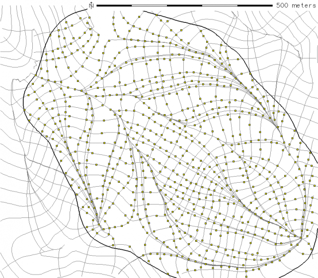
Establishing the Optimal Number of Survey Points
First Pass: Terrain Skeleton
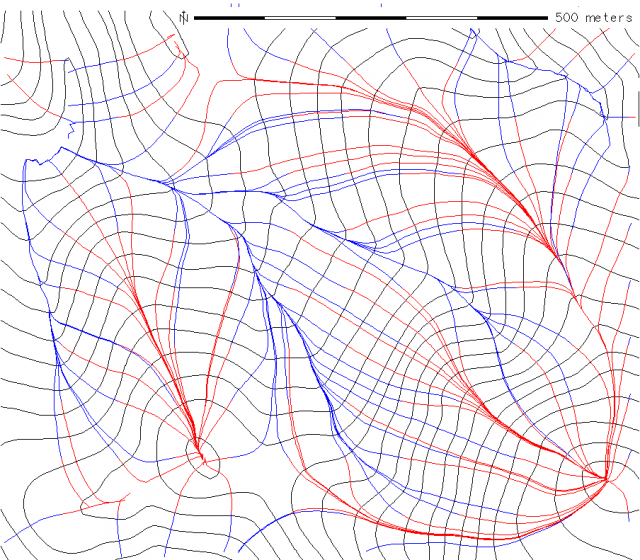
Terrain Skeleton
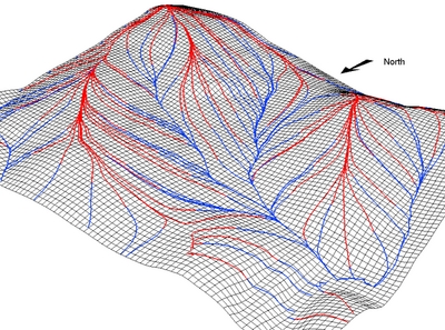
Terrain Skeleton 3D
Initial Estimation
- 50 meter interval sampling of contours
- 10 meter interval sampling of terrain skeleton
- 15 meter thinning (snapping) radius
# generate a slightly larger watershed, so that we get the edges
v.buffer in=w_smooth out=w_buff buffer=50 --o

# setup some kind of sampling intervals
contour_sampling_interval=50
skeleton_sampling_interval=15

# create a set of points along contours
v.to.points -i -t in=contours out=cp dmax=$contour_sampling_interval --o

v.category in=cp out=cp_cat option=del --o
v.category in=cp_cat out=cp_cat_1 option=add --o

# select only those within the watershed:
v.select -t ainput=cp_cat_1 atype=point binput=w_buff btype=area operator=overlap out=contour_pts --o


# create set of points from terrian skeleton
# note that the output from r.flow involves multiple line segments that converge
# and thus is not readily converted to a regular interval of points

# combine flow and upflow
v.patch in=flow,upflow out=skel

# convert to points on a regular interval
# use a small number to preserve the complexity--
# we will thin the number of points down later
v.to.points -i -t in=skel out=sp dmax=10 --o


# these points need a category first
#
v.category in=sp out=sp_cat option=del --o
v.category in=sp_cat out=sp_cat_1 option=add --o


# select only points within watershed
v.select -t ainput=sp_cat_1 atype=point binput=w_buff btype=area operator=overlap out=skel_pts --o


# give each sampling point a unique ID and attr designating the observation type:
v.db.addtable skel_pts
v.db.addtable contour_pts

v.db.addcol skel_pts column='pt_type varchar(10)'
v.db.addcol contour_pts column='pt_type varchar(10)'

echo "update contour_pts set pt_type = 'contour'" | db.execute
echo "update skel_pts set pt_type = 'skel'" | db.execute


# patch contour and skeleton sampling points
v.patch -e in=contour_pts,skel_pts out=rp
v.build rp

# thin points out a bit
v.clean in=rp out=rtk_pts tool=snap thres=$skeleton_sampling_interval --o

# cleanup temp points:
g.remove vect=cp,cp_cat,cp_cat_1,sp,sp_cat,sp_cat_1,rp


# simple map
d.erase
d.vect contours col=grey
d.vect skel col=grey
d.vect w_buff width=2 type=boundary

# sample points
# d.vect contour_pts icon=basic/box fcol=yellow
# d.vect skel_pts icon=basic/box fcol=red

# combined sample points:
d.vect rtk_pts icon=basic/box fcol=yellow

# d.barscale -m
# d.out.file intial_plan --o


# how many points are we talking about ?
eval `v.info rtk_pts -t | grep points`
echo $points

# 832